The history of the North Mississippi Hill Country begins long before the first white settlers arrived in the region. The fields, rivers and hills of North Mississippi were the ancestral homelands of the Chickasaw Indians. According to the Chickasaw origin story, the Chickasaw migrated to this region from west of the Mississippi River. Many modern historians and archaeologists now believe that the Chickasaw (and other Southeastern Native American tribes) are directly descended from earlier Mississippian culture “Mound Builders”, who constructed many earthen mounds for religious, social or military purposes.
By the year 1500, the Chickasaw were firmly established in northeast Mississippi, likely in the area around Starkville, West Point and Columbus, Mississippi. In 1540, Spanish explorer Hernando de Soto became the first European to encounter the “Chicaza”, as the tribe called itself. After a disastrous trade negotiation, the Chickasaw attacked de Soto’s expedition, and de Soto quickly continued west. It would be another 150 years before the Chickasaw encountered another group of Europeans: this time the French, led by explorer Robert La Salle in 1682. Also, by 1690, the Chickasaw had begun trading with the English colonists from the Carolinas.

Eventually, the Chickasaw moved further north to the area around Pontotoc and Tupelo, Mississippi, in the areas that would eventually be called the “Chickasaw Old Fields”. By 1720, the Chickasaw had allied with the British, whom they traded with exclusively, while their enemies the Choctaw had allied with the French. An alliance of Choctaw and French attacked and nearly destroyed the Natchez tribe, supporters of the Chickasaw and British, in 1729. The surviving Natchez sought protection from the Chickasaw. In 1736, the French were determined to annihilate the Chickasaw, and began a two-prong attack against the Chickasaw homeland in northeast Mississippi. Pierre D’Arteguiette was defeated at the battle of Ogoula Tchetoka in March and executed along with the surviving French, and in May the southern army, led by Jean Baptiste Bienville, was defeated at the battle of Ackia. After the French and Indian War (1754-1763) resulted in France’s total defeat, the Chickasaw were finally free from French antagonism, and even established peace with their long-time enemies, the Choctaw.
The mid-18th century saw a steady stream of independent British traders and explorers arriving in Chickasaw lands. Two of these Europeans had a particularly strong influence on the history of the Chickasaw. James Logan Colbert, a Scottish trader from North Carolina, settled in Alabama in about 1729 and soon married a Chickasaw wife. James Colbert eventually married twice more, and had eight children who were half Chickasaw and half white. Thomas Love was a British Loyalist who fled the American Revolution in the early 1780s. Thomas married twice, and had at least ten children. The family eventually moved to what would eventually become Marshall County, Mississippi. The Colbert and Love family were soon united when Sally Colbert, the daughter of James Colbert, married Thomas Love. Though the Colbert and Love children were mixed-blood, the Chickasaw were matrilineal, and the children were fully accepted by the tribe. Over the next 75 years, both families would play important roles in the Chickasaw hierarchy.

During the American Revolution, the Chickasaw allied with the British against the American colonists, though there was only one minor skirmish between the Chickasaw and Americans during the War, resulting in the normalization of relations between the Chickasaw and United States soon after Independence. The treaty of Hopewell, in 1786, was the beginning of official relations between the Chickasaw and the United States. The treaty officially established the boundaries of the Chickasaw Nation, to include the homelands of northwest Arkansas and North Mississippi and the traditional hunting grounds of West Tennessee and west Kentucky.
In 1798, the Mississippi Territory was established, resulting in the areas of southern Mississippi and Alabama coming under the direct control of the United States. After Thomas Jefferson was elected as the third President of the United States, the U.S. Government’s policy towards the Chickasaw and other Indian tribes changed drastically. In an attempt to open up new lands to white settlers, the Government forced the Chickasaw to agree to several land cessions. The first cession occurred in 1804, when the Chickasaw sold portions of the lands in middle Tennessee and southern Kentucky in exchange for the United States paying off Chickasaw debt. After the end of the War of 1812, General Andrew Jackson negotiated with the Chickasaw leaders, George and Levi Colbert, for a second Chickasaw Cession in 1816 and 1818, resulting in the loss of all Chickasaw lands outside of the traditional homeland of North Mississippi.

The year 1828 heralded the beginning of the end for Chickasaw sovereignty. In that year, Andrew Jackson was elected President of the United States. Two years later, in 1830, the United States Congress passes the Indian Removal Act, codifying the Government’s official policy of removing all Native Americans from territories east of the Mississippi River. In that same year, the Chickasaw’s old enemies, the Choctaw, signed the Treaty of Dancing Rabbit Creek with the United States, resulting in the loss of all Choctaw land in Mississippi. Between 1830 and 1833, most of the Choctaw were forced to resettle in Indian Territory (Modern Oklahoma), with over 2,500 Choctaw dying on the “Trail of Tears”. By 1830, the Chickasaw Nation was the last remaining sovereign Indian nation in Mississippi.

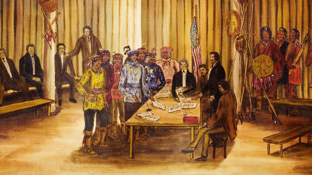
In August of 1830, Chickasaw leaders and the United States signed the treaty of Franklin which would result in the Chickasaw selling all of their remaining land and resettling in Indian Territory. The Treaty of Franklin was never ratified by Congress, and two years later, on October 20, 1832, the Chickasaw leaders and United States Representatives signed the Treaty of Pontotoc Creek, at the Chickasaw Council House outside modern day Pontotoc. The Chickasaw delegation was led by Levi and George Colbert. Two years later, a supplemental treaty was signed by the Chickasaw and the United States. The Chickasaw delegation in this final treaty was led by George Colbert and Benjamin Love, among others. The result of both of these treaties was the near total removal of Chickasaw Indians west of the Mississippi River and the loss of the Chickasaw homelands. The actual removal of Chickasaws occurred between 1837 and 1838.
In between the two Chickasaw treaties with the United States, efforts were underway to begin the process of surveying and dividing the new “Chickasaw Cession”. In 1833, President Jackson appointed John Bell as surveyor general for the Chickasaw Cession, and also appointed Robert Tinnin as register and William Forbes as receiver. By early 1834, the Pontotoc Land Office had been constructed, several miles from the site of the earlier Treaty of Pontotoc Creek.
By mid-1834, the survey of the Chickasaw Cession had begun. Deputy surveyors, working under John Bell, travelled throughout the Cession and began dividing the area into six-mike Square townships, which would further be divided into 36 one-mile sections. As per the Treaty of Pontotoc, the various Chickasaw families residing in the Cession would receive a reservation of one-third of the available land, while the rest would be sold at auction to the highest bidder.

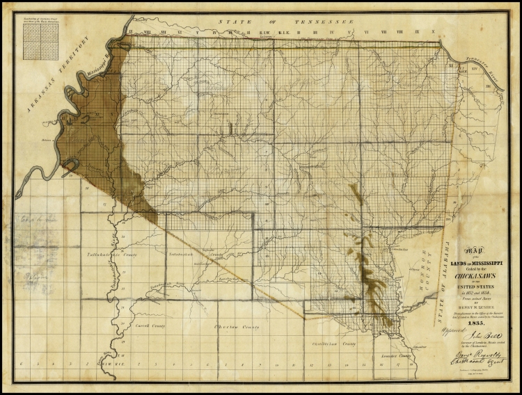
By 1835, the Chickasaw Cession had been fully surveyed and mapped. It then fell to Henry M. Lusher, the draftsman of the Pontotoc Land Office, to plat the lands that had been surveyed by John Bell and the deputy surveyors. The “Lusher Map” was finished and published in 1835, and is the first detailed map drawn of North Mississippi. By the end of 1835, a small town had risen up around the original land offices in Pontotoc, including a tavern, a post office, offices for land companies, a branch of the Chickasaw Agency and more.
The first land sale occurred in January of 1836. Nearly a million acres were sold at this sale. In February, the Mississippi Legislature authorized the creation of the original ten counties of the Chickasaw Cession: Desoto, Tunica, Panola, Marshall, Lafayette, Tippah, Tishomingo, Pontotoc, Itawamba and Chickasaw. A second land sale occurred towards the end of 1836, resulting in the sale of over 2.6 million acres. New land offices were being opened in every new Chickasaw Cession county, and the first towns were being founded. By the end of 1837, the last surveys of the Cession had been completed, and three years later, in 1840, the Surveyor General’s office was closed. The Pontotoc Land Office, from which the entire Chickasaw Cession and all of the current North Mississippi counties originated, was finally closed for good in 1854, with the land occupied by the offices eventually incorporated into the town of Pontotoc.